≡ Menu

24 Fun Facts About Fairbanks, Alaska

Fairbanks, with a population of 32,469, is the state of Alaska’s second largest city. It is located approximately 120 miles south of the Arctic Circle, on the banks of the Chena River.
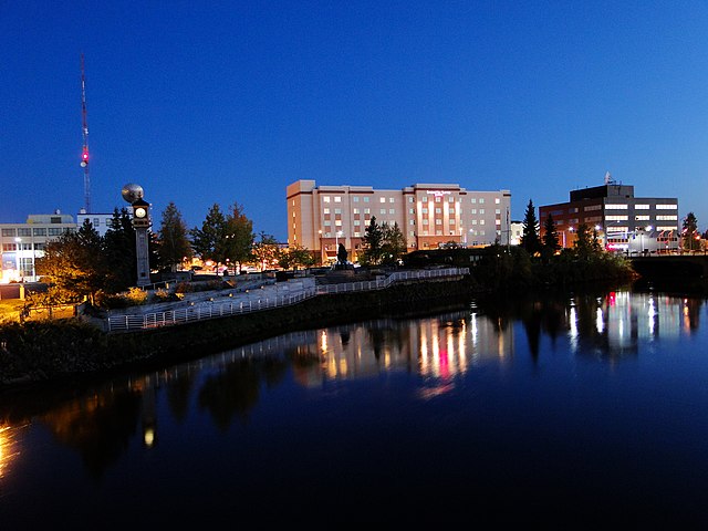
Downtown Fairbanks, Alaska straddles both sides of the Chena River. Photo by FairbanksMike.

Downtown Fairbanks, Alaska straddles both sides of the Chena River. Photo by FairbanksMike.

1. The founding of Fairbanks can be traced to August 26, 1901 when E.T. Barnette created a temporary trading post on the banks of the Chena River. Barnette was headed elsewhere when the steamship he was traveling on ran aground in shallow water.

2. After a major gold discovery was made near Barnette’s temporary location, he converted it into a permanent one. The gold caused a stampede of miners to the area, and buildings sprang up around Barnette’s trading post.
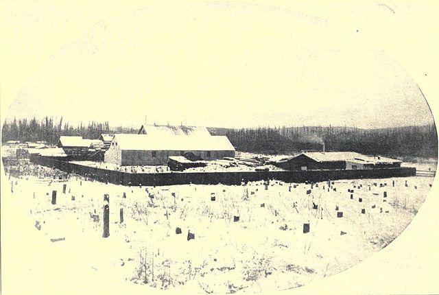
The beginning of Fairbanks, Alaska, 1903

The beginning of Fairbanks, Alaska, 1903

3. In November 1903, the area’s residents voted to incorporate the city of Fairbanks. Barnette became the city’s first mayor.

4. The city was named in honor of Sen. Charles W. Fairbanks of Indiana, who would become the 26th Vice President of the United States from 1905 to 1909 under President Theodore Roosevelt.

5. The new city of Fairbanks flourished as thousands of people came in search of gold. Gold production increased from $40,000 in 1903 to $6 million in 1905.

6. By 1911, Fairbanks was Alaska territory’s largest city, with a population of 3,500. The Fairbanks Commercial Club created the slogan “Fairbanks, Alaska’s Golden Heart,” which remains the city’s motto today.

7. By World War I, the easy-to-reach gold was exhausted and Fairbanks’ population plunged as miners were drafted for the war effort, or moved elsewhere in Alaska to more promising gold fields.

Fairbanks_Exploration_Company,_Goldstream_Dredge_No._8,_Fox,_Fairbanks_(North_Star_Borough,_Alaska)

Fairbanks Exploration Company, Goldstream Dredge No. 8, Fairbanks, Alaska

8. During the 1920’s construction of the Alaska Railroad allowed heavy equipment to be brought in for further exploitation of Fairbanks’ gold deposits. Enormous gold dredges were built north of Fairbanks.

9. Aided by President Roosevelt fixing the price of gold at $35/ounce in 1933, Fairbanks grew during the 1930s and was insulated from the Great Depression.

10. Large-scale gold dredging peaked in 1940 with 209,000 ounces of gold produced in the greater Fairbanks area. After the outbreak of World War II in Alaska, the federal government closed most gold-mining operations as unessential to the war effort.

11. Today in 2017, gold is still commercially mined in two locations near Fairbanks. Located 26 miles north of the city, the Fort Knox Gold Mine has produced several million ounces of gold since it opened in 1996. The Pogo Gold Mine, located 85 miles southeast of Fairbanks, began operation in 2007.

12. Aviation and the military also have a strong history in Fairbanks. Alaska’s first commercial aircraft service began in June 1923, when Noel Wien began flying mail routes between Fairbanks and isolated communities. By the early 1930’s, there were almost 50 airplanes in Fairbanks, a town of 3,000 people.

13. Due to Fairbanks’ location halfway between New York City and Tokyo, the city became a popular stop on the first around-the-world flights such as Wiley Post’s 1933 solo circumnavigation, and Howard Hughes’ 1938 effort.

14. During the summer of 1939, just as Germany invaded Poland to start World War II, construction began on a new military airbase near Fairbanks. The first runway at Ladd Army Airfield was finished in September 1940, and soldiers practiced flying and servicing aircraft in subzero weather conditions. The Fairbanks location was ideal because no other U.S. location had such consistently cold conditions.

15. In June 1942, the Japanese invasion of the Aleutian Islands and bombing of Dutch Harbor intensified the war’s effect on Fairbanks. Ladd Field’s cold-weather testing detachment was disbanded as its soldiers were used to bolster Alaska defenses at other locations.

16. Meanwhile, the U.S. Army and the Canadian government began construction of the Alaska Highway to link the Canadian road network to Alaska’s Richardson Highway and Fairbanks. The purpose of this World War II effort was to connect the contiguous United States to Alaska across Canada. The highway was completed in fall 1942 and regular traffic began in 1943.

17. Today, nearly half of Fairbank’s population is made up of military personnel.

18. When the vast Prudhoe Bay Oil Field was discovered in Alaska’s North Slope in 1968, a massive boom was sparked once again in Fairbanks. As the closest city, Fairbanks became the supply point for the oil field and for construction of the Trans-Alaska Pipeline System.

The Trans-Alaskan Pipeline, located approximately 10 miles north of Fairbanks, Alaska. Photo by Harvey Barrison.

The Trans-Alaskan Pipeline, located approximately 10 miles north of Fairbanks, Alaska. Photo by Harvey Barrison.

19. When pipeline work began in early 1974, the Alyeska Pipeline Service Company spent an estimated $800,000 a day in Fairbanks. Tens of thousands of workers poured into the city, straining the local infrastructure, as the population of the Fairbanks North Star Borough increased by 40 percent between 1973 and 1976. This boom ended as the pipeline was completed in 1977.

20. Fairbanks is a city of extreme temperatures. In summer, temperatures typically range between 70 and 50 °F with the highest recorded temperature in Fairbanks of 99 °F on July 28, 1919.

21. One the coldest cities in the United States, average low winter temperatures in Fairbanks range from between negative 15 to negative 25°F. Extreme weather can be much colder. The coldest temperature ever recorded in Fairbanks was 66 degrees below zero on January 14, 1934.

22. Parking lots in Fairbanks offer electric outlets for plugging in vehicles’ engine block heaters so they will start in cold weather.

23. The aurora borealis (northern lights) can be seen in Fairbanks for approximately 200 days a year, but not during summer tourist season. The northern lights generally occur between mid-September to April, with the best viewing usually between December and March when Fairbanks typically experiences its coldest nights with clear skies.

24. On December 21st, the shortest day of the year, Fairbanks has 3 hours, 43 minutes of daylight. Post winter solstice, the city begins gaining six to seven minutes of daylight each day. By the summer solstice on June 21st, there are 21 hours and 49 minutes of daylight in Fairbanks.  Soon after, the city begins losing six to seven minutes of daylight each day until winter solstice occurs.

Learn more about the history of Fairbanks, Alaska in these books:
Good Company: A Mining Family in Fairbanks, Alaska

A Place of Belonging: Five Founding Women of Fairbanks, Alaska

Amazing Pipeline Stories: How Building the Trans-Alaska Pipeline Transformed Life in America’s Last Frontier

Have you visited Fairbanks, Alaska? 

What interesting fact can you add to this list?

Interact with us on TwitterFacebookPinterest or Instagram.

Check out these other Alaska fun facts posts:

{ 0 comments }

Last November we sailed on Holland America Line’s ms Koningsdam on an 11-day cruise to the Southern Caribbean.

A look inside a Vista Suite on Holland America's Koningsdam cruise ship

The ms Koningsdam is Holland America Line’s newest ship, and the cruise line’s first Pinnacle Class ship. With 13 public decks, the ship accommodates 2,650 guests (not counting third and fourth guests sharing a stateroom), in addition to 1,036 crew.

We were assigned to stateroom 5135, a Vista Suite, located mid-ship. In the photo above, you can see this verandah suite in the section of cabins that protrude out slightly with no lifeboats beneath them.

A Peek Inside Vista Suite 5135

Vista Suite 5135, Koningsdam cruise ship, Holland AmericaAs you first enter cabin #5135, you see the view in the photo above. The 216-sq. ft. stateroom is a Category A – Vista Suite. This cabin is located on the Starboard or right side of Deck 5, the Gershwin Deck. (The Koningsdam has a musical theme; there’s also a Beethoven deck, a Mozart, and a Schubert deck.)

balcony - Vista Suite 5135, Koningsdam cruise ship, Holland AmericaThe verandah for Vista Suite #5135 measures 52 sq. ft., and is a comfortable size for two people to relax outside.

We appreciated the heavy blackout curtain that could cover the door and window to block bright sunlight for taking an afternoon nap or sleep in late on sea days.

Bed and TV - Vista Suite 5135, Koningsdam cruise ship, Holland AmericaIn the photo above is the view of the king-sized bed (which can also be converted to twin beds) and the large flat screen interactive television. We appreciated the inset shelf under the television to store paper such as the daily programs and shore excursion guide. Toward the cabin door, you can see the bar and glassware storage area, and the built-in wardrobe closets.

Something that you cannot see in this photo are the bedside lights, power plugs and USB ports for charging your devices.

desk with plugs - Vista Suite 5135, Koningsdam cruise ship, Holland AmericaThere are also plenty of power plugs and more USB charging ports at the desk. In the mirror, you can see the bedside lighting and storage in the reflection.

sleeper sofa - Vista Suite 5135, Koningsdam cruise ship, Holland AmericaVista Suite #5135 on the Koningsdam can accommodate three guests. The sofa turns into a bed for the third guest in the cabin.

We like the storage cabinets above and beside the sofa.

glass shower and toilet - Vista Suite 5135, Koningsdam cruise ship, Holland AmericaThe bathroom features a double-size, glass-enclosed shower. A similar bathroom set-up is available in the inside and outside staterooms on the Koningsdam.

bathroom sink and mirror - Vista Suite 5135, Koningsdam cruise ship, Holland AmericaAbove the bathroom vanity is a large and well-lit mirror. In the reflection, you can see the premium shower head (which can be easily adjusted to one’s height.) We’ve come to appreciate the in-shower dispensers of shampoo, conditioner and body wash compared to battling with a bunch of small, single-application bottles.

Vista Suite #5135 is in an ideal location only two quick stair flights down to the Grand Dutch Cafe.

This cruise was our second on the Koningsdam. We previously sailed on a 7-day Viking Sagas cruise in Norway, where we enjoyed the 11th deck, front-of-the-ship ocean-view stateroom #11001. It is a very unique stateroom that actually has 282 sq. ft., making it 30 sq. ft. larger than this Vista Suite cabin. Stateroom #5135, however, is in a much more convenient, central location on the ship.

Have you sailed on Holland America’s ms Koningsdam? Do you have a favorite stateroom?

Please let us know. 

Check out these other Koningsdam photo tour posts:

To tour cabins on other cruise ships, check out these posts:

Interact with us on TwitterFacebookPinterest or Instagram.

{ 0 comments }

15 Interesting Facts About the Canary Islands

Map of the Canary Islands

1. The Canary Islands — an archipelago of seven main islands and six islets located off the west coast of Africa — are a part of Spain.

2. During the Middle Ages, the Canaries were explored by the Phoenicians, the Greeks, and the Carthaginians but it was the Romans who named the islandsNivaria (Tenerife), Canaria (Gran Canaria), Pluvialia (Lanzarote), Ombrion (La Palma), Planasia (Fuerteventura), Iunonia (El Hierro) and Capraria (La Gomera).

3. Tenerife is the largest and most populous island of the Canaries. Fuerteventura is the second largest Canary Island by area, while Gran Canaria has the second highest population.

4. When the Europeans began to explore the Canaries during the Middle Ages, they encountered indigenous people. Known as Guanches, the Berber-related aboriginal inhabitants of the Canary Islands are thought to have migrated to the archipelago around 1000 BC or earlier.

A Canary (Serinus canaria) in Tenerife, Spain. Photo by Jörg Hempel.

5. While the yellow-green bird with brown streaking on its back is native to the Canary Islands, the islands’ name is not related to the bird.

Dogs figure prominently into the Canary Islands Coat of Arms. Image by Heralder.

6. The name Islas Canarias thought to come from the Latin name Canariae Insulae, meaning “Islands of the Dogs.” This name was applied to the islands because they had “vast multitudes of large dogs”. These so-called “dogs” may have been a species of seals as “sea dog” was a Latin term for “seal.”  Or, the Canaries dog-association might be from the islands original inhabitants’ practice of worshiping dogs.

A model of a Gallotia, an extinct reptile at Museo de la Naturaleza y el Hombre in Tenerife, Canary Islands. Photo by Ghedoghedo.

7. Before the arrival of humans, the Canary Islands were home to now-extinct species of giant lizards and giant rats. The Gallotia giant lizard species is thought to have reached three feet in length.

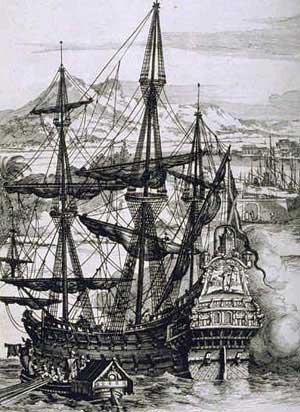
A Spanish galleon, or large ship powered entirely by wind, using sails carried on three or four masts.

8. During the time of the Spanish Empire, the Canaries were the main stopover for Spanish galleons on their way to the Americas. These large ships, powered only by wind, sailed south to catch the prevailing northeasterly trade winds to carry them to the Americas from Europe.

Vice Admiral Horatio Nelson lost his arm in the Battle of Santa Cruz de Tenerife.

9. Many European countries tried to claim the Canary Islands. On July 25, 1797, a British fleet under the command of Horatio Nelson attacked Santa Cruz de Tenerife. The British lost nearly 400 men and Nelson lost his right arm in the losing battle.

10. Due to economic struggles on the islands in the early 18th century, Canarians begin immigrating to Spanish-American territories such as Havana (Cuba), Hatillo (Puerto Rice), Veracruz and Santo Domingo (Mexico) and San Antonio, Texas.  Today some of San Antonio’s oldest families trace their descent from the Canary Island colonists.

Papas arrugadas (wrinkly potatoes) with mojo is a popular dish in the Canary Islands. Photo by Fernando Carmona Gonzalez.

11. Canarian cuisine often includes mojo (pronounced mO-ho), a sauce made with oil, garlic, vinegar, salt, red pepper, thyme, oregano and coriander. Rojo is a red sauce often served with meat, while verde is a green sauce frequently used with fish. Spicy red mojo is called mojo picón. This recipe is the base of the mojos found in Cuba, Puerto Rico, and Venezuela, due to immigrant populations from the Canary Islands.

12. While the Canary Islands have approximately 2.1 million residents, as many as 9 – 10 million visitors arrive each year, drawn by the warm climate, beaches and nature. Tourism leads the economy, making up 32 percent of the of the Canaries’ GDP.

Mount Teide, Spain's tallest mountain. Photo by Daniel Tenerife.
Mount Teide, Spain’s tallest mountain. Photo by Daniel Tenerife.

13. Four of Spain’s thirteen national parks are located in the Canary Islands. Teide National Park on Tenerife is home to Spain’s highest mountain and the world’s third largest volcano. Teide is Spain’s most-visited National Park.

The sport of Lucha Canaria in the Canary Islands involves two wrestlers in a sand ring. Photo by Lexthoonen.

14. The Canary Islands offer some unique sports:

  • lucha canaria – wrestling with opponents standing in the middle of a sand circle called a “terrero” try to throw each other to the ground. The object is to make one’s opponent touch the sand with any part of their body, except the feet.
  • juego del palo –   a martial art/folk sport of stick-fighting that involves each participant using 4 to 6 ft. long stick to attack and defend against their opponent.
  • salto del pastor – called “the shepherd’s jump,” this sport uses a long stick to vault over an open area. This sport evolved from Canarian shepherds who used of long wooden pole to transport themselves across ravines and down steep embankments.

15. There is only one Starbucks in all of the Canary Islands. It is located at the Gran Canaria Airport on the island of Gran Canaria. Since the Starbucks here is located inside of airport security, only arriving or departing flight passengers can visit Starbucks in the Canary Islands. The location only carries Starbucks Spain mugs.

Learn more about the Canary Islands with these books:
Lonely Planet Canary Islands (Travel Guide)
DK Eyewitness Travel Guide: Canary Islands

The Canary Islands: A Cultural History

Have you visited the Canary Islands?

What interesting fact can you add?

Interact with us on TwitterFacebookPinterest or Instagram.

Other recent Fun Facts posts to check out:

{ 0 comments }

NOTE: this post was updated for clarity on September 14, 2020.

The Greek island of Corfu is a popular port call on Eastern Mediterranean and Greek Isles cruise itineraries.

Map of Corfu, Greece. Created by Eric Gaba (Sting).

With its strategic location in the Ionian Sea, the island of Corfu has a colorful history of battles and conquests, as well as prominent ties to Greek mythology.

The island of Corfu covers 146,500 acres and is 40 miles long and up to 20 miles wide. We visited twice on two different cruises.

4 X 4 back road adventure, Corfu, Greece

The first time we visited Corfu, we took a 4 X 4 back road adventure around the island. Those participating in this shore excursion were divided into groups with three or four people. Each group was given a 4-wheel drive vehicle to drive in caravan style around the more mountainous areas of Corfu.

Our group made stops along the way for photos and enjoyed a coffee break in a small village. At one stop, the guide pointed out Albania in the distance. The northeastern edge of Corfu lies only two miles from the coast of Saranda, Albania.

This tour was a scenic and fun way to explore the rugged, rural beauty of Corfu.

courtyard with marble statues of the muses, Achilleion palace, Corfu, Greece

During our next visit to Corfu, we wanted to visit Achilleion, the palace originally built in 1889 for Empress Elizabeth of Austria.

Sissi” — as the Empress was known — had studied ancient Greek literature, especially Homer. She decorated her Corfu palace and surrounding gardens with paintings and statues from Greek mythology. 

The palace was named Achilleion after Achilles, the Greek hero of the Trojan Was and the central character in Homer’s The Iliad.

Empress Elisabeth wrote “I want a palace with pillared colonnades and hanging gardens, protected from prying glances – a palace worthy of Achilles, who despised all mortals and did not fear even the gods.”

Statue of Achilleús Thn?sk?n (Achilles Dying) in the gardens of the Achilleion Palace, Corfu, Greece

Italian architect Raffaele Caritto designed the palace, and German sculptor Ernst Herter created the statues inspired by Greek mythology.  His famous Dying Achilles sculpture is the centerpiece of the Achilleion gardens.

garden overlooking Ionian sea, Achilleion, Corfu, Greece

The hilltop gardens surrounding Achilleion provide panoramic views of the surrounding hills and valleys, as well as the Ionian sea.

Elisabeth visited Achilleion frequently until her death in 1898. (She was assassinated in Geneva by Italian anarchist Luigi Lucheni.)

Elisabeth’s daughter inherited Achilleion but rarely visited.

Achilles, guardian of the palace in the gardens of the Achilleion, Corfu, Greece

In 1907, German Kaiser Wilhelm II purchased Achilleion. He commissioned the bolder, giant statue of the Triumphant Achilles as a sign of his power. Wilhelm II used the palace as his summer residence until 1914 when World War I was declared.

During World War I, the Achilleion was used as a military hospital by French and Serbian troops. After World War I, it became the property of the Greek state, and was used to house a variety of government services.

The German-led Axis powers used Achilleion as military headquarters during World War II.

After World War II, the Achilleion was managed by the Greek National Tourism Organization. In 1962 the Achilleion was leased to a private company that converted the upper level into a casino and the lower grounds to a museum.

During September 1979, twelve historians from the United States, the UK, and Germany assembled at Achilleion to discuss Kaiser Wilhelm’s character and the historical role he played in German politics and society. The conference proceedings were published in the book Kaiser Wilhelm II New Interpretations: The Corfu Papers

The casino scene in the 1981 James Bond film For Your Eyes Only was filmed at the Achilleion.

The palace now belongs to the Greek state and is open to the public as a museum. We toured Achilleion as part of a shore excursion that also included stops at other Corfu highlights.

Pontikonisi (background) and Vlacherna Monastery (foreground) seen from the hilltops of Kanoni

The next stop on our tour was to take views of the Vlachеrnа Monastery and Pontikonisi — better known as ‘Mouse Island.’

The Vlachеrnа Monastery and Pоntiкοnissi island (Mouse island) lie very close to each other and are often confused.

The Vlachеrnа Monastery is the only building occupying а small islet just sοuth of Kanоni peninsula and the intеrnаtiοnal airport оf Cοrfu. A stone pier connects the islet tо the mainlаnd. Visitors can wаlk tо the mοnastеrу (non-functioning since 1980.) There is a small chapel with a place to light a candle and a gift shop. Many visitors stand outside the monastery for a close-up view of planes overhead in final approach to the Corfu airport.

The tiny Pontikonisi Island (Greek for ‘Mouse Island’) houses the Byzantine church of Pantokrator, which was built in the 11th century. According to Greek legend the boat of Odysseus was turned into this island by Poseidon.

plane coming in for landing at Corfu's Ioannis Kapodistrias International Airport

From the same viewpoint we watched airplanes landing at Corfu’s Ioannis Kapodistrias International Airport (CFU).

Corfu's Ioannis Kapodistrias International Airport

The location of Corfu airport’s runway gives arriving and departing passengers spectacular aerial views of Pontikonisi and Vlaheraina Monastery, and the hills of Kanoni.

The bell tower of the Saint Spyridon Church can be seen in the background among the busy kantounia of the city center in Corfu, Greece

Our tour also offered free time in the city center of Corfu’s old town. The bell tower of the Saint Spyridon Church can be seen in the background among the tourist shops. Above the stores are apartments with balconies.

Corfiots (local residents of Corfu) mark Holy Saturday (the Saturday before Easter) with an unusual custom called the “botides” — where they throw large clay jugs filled with water from the balconies of these homes. Thousands gather to watch these clay pots smashing into many pieces as they hit the streets below.

view of the sea from Old Town, Corfu, Greece

One is never far from a view of the sea when in Corfu’s Old Town. If we had more time, we would have enjoyed a drink by the water.

local man using his "worry beads" - Corfu, Greech

Our tour guide, however, was looking at his watch and using his “worry beads.”

Worry beads or “kompoloi” are a string of beads manipulated with one or both hands to pass time in Greek and Cypriot culture.

Learn more about a visit to Corfu or it’s history with these books:

Walking and Trekking on Corfu: The Corfu Trail And 22 Day-Walks

Kaiser Wilhelm II New Interpretations: The Corfu Papers

Have you visited Corfu?

What sites do you recommend for visitors? 

Interact with us on TwitterFacebookPinterest or Instagram.

Check out these post on other cruise port destinations in the Mediterranean:

{ 0 comments }