≡ Menu

Athens, the capital and largest city of Greece, is known as the “cradle of Western civilization” and “the birthplace of democracy.”

We’ve visited Athens several times via a cruise ship call to nearby Piraeus, Greece’s main port, reaching the Acropolis by either tour bus or the metro line.

the Parthenon on the Acropolis of Athens in the city of Athens, GreeceOne of the world’s oldest cities, Athens emerged as a city state around 800 BC, although the area around the Acropolis had its earliest human presence more than 7,000 years ago.

the Parthenon on the Acropolis of Athens in the city of Athens, GreeceIn the mid-5th century BC, guided by democratic leader Pericles, Athens embarked on building the Acropolis including the Parthenon.

The Caryatid Porch of the Erechtheion, Athens, 421–407 BC

The Caryatid Porch of the Erechtheion, Athens, 421–407 BC

During this Golden Age of Athenian democracy, Pericles promoted the arts. Playwrights Aeschylus, Sophocles and Euripides flourished, as did Herodotus and Thucydides, as well as Hippocrates and Socrates.

 Odeon of Herodes Atticus, Athens, Greece The Odeon of Herodes Atticus is a stone theater on the southwest slope of the Acropolis of Athens. Built in 161 AD by the Athenian magnate Herodes Atticus in memory of his wife, this theater had a capacity of 5,000 and was used for music concerts.

Odeon of Herodes Atticus, a stone theatre located on the southwest slope of the Acropolis in Athens, GreeceToday, the Odeon of Herodes Atticus is the main venue for the Athens Festival between May and October each year. A number of international artists have performed at the venue including Sting during his 1996 Mercury Falling Tour, and Elton John during his Medusa Tour in 2000. The theater also hosted the 1973 Miss Universe pageant.

Temple of Hephaestus, AthensVisitors to the top of the Acropolis are rewarded with a terrific view of Temple of Hephaestus, the best-preserved of all ancient Greek temples. A Doric temple, it remains standing largely as built when completed in 415 BC.

Panathenaic Stadium, Athens, GreeceThe Panathenaic Stadium in Athens is the world’s only stadium built entirely of marble. It was built with 50,000 seats by Athenian Roman senator Herodes Atticus in 144 AD. Abandoned in the 4th century, the stadium was excavated in 1869 and hosted the 1870 and 1875 Zappas Olympics.


Olympic statue, Athens, GreeceThis stadium hosted the opening and closing ceremonies of the first modern Olympics in 1896. It was used again as a venue for the 2004 Summer Olympics.

It is also the last venue in Greece from where the Olympic flame handover ceremony to the host nation takes place.

relaxing with a beer after exploring the Plaka and Monastiraki areas of Athens, GreeceThe Plaka and the Monastiraki neighborhoods — at the base of the Acropolis — are filled with shopping, dining, and scenic spots for a cold beer.

Are you planning a visit to Athens? Learn before you go with these books:

DK Eyewitness Travel Guide: Greece, Athens & the Mainland

The Plague of War: Athens, Sparta, and the Struggle for Ancient Greece

Have you visited Athens? 

What was your favorite view?

We welcome you comments.

Interact with us on TwitterFacebookPinterest or Instagram.

{ 0 comments }

The photos are intriguing.

Corinth Canal, Greece

The four-mile-long Corinth Canal through Greece connects the Gulf of Corinth with the Saronic Gulf in the Aegean Sea.

Only 70 ft. wide at sea level, the canal expands to a width of 81 ft. at top of its 300 ft. high rock walls.

A small cruise ship transits the Corinth Canal. Photo by Ernmuhl

Only ships with a width of 58 ft. or less can transit the Corinth Canal.

Although the canal saves the 430-mile journey around the Peloponnese, it is too narrow for modern ocean freighters.

Map of the Isthmus of Corinth by EcoChap.

Since it separates the Peloponnese from the Greek mainland, the creation of the Corinth Canal made the former Peloponnese peninsula into an island.

An aerial view of the Corinth Canal. Photo by Philos2000.

A railway line, a road and a motorway all cross the Corinth Canal. 

In 1988, a sea-level submersible bridge was installed at each end of the canal, by the eastern harbor of Isthmia and the western harbor of Poseidonia.

While the Corinth Canal was not completed until 1893, rulers during classical Greek times dreamed of digging a cutting through the Isthmus.

As he worked to build Corinth into one of the major trading centers of Ancient Greece, tyrant Periander first attempted to dig a canal during the 7th century BC. When the canal project proved difficult, Periander switched effort to a less expensive overland portage road, named the Diolkos. With this stone carriageway, ships could be towed across the Isthmus of Corinth, and tolls could be collected from goods entering Corinth’s port.

In 67 AD, Roman Emperor Nero attempted to construct the canal, personally breaking the ground with a pick axe and removing the first soil. The Roman workforce, consisting of 6,000 Jewish prisoners of war, began digging 130–160 ft. wide trenches from both sides, while a third group at the ridge drilled deep shafts to probe the quality of the rock.

Although the effort was abandoned after Nero’s death, a memorial of the attempt left by Nero’s workers can still be seen today in the canal cutting.

The Inauguration of the Corinth Canal in 1893. Painting by Greek painter Constantinos Volanakis (1837-1907).

While considered over the years, construction on the canal did not start again until 1881. The Corinth Canal was finally completed and inaugurated in 1893.

After its opening, the Corinth Canal failed to attract the expected ship traffic for multiple reasons:

  • The canal is tough to navigate because it’s narrow, with frequent high winds and strong currents.
  • The canal’s high rock walls were subject to landslides; the canal was closed multiple times between 1893 and 1940 for work to stabilize its walls.

The canal was damaged during World War II due to its strategic importance. In 1944, as German forces retreated from Greece, they used explosives in “scorched earth” operations to put the canal out of action and to hinder repair work.

During November of 1947, the United States Army Corps of Engineers began work to clear the canal. It was re-opened it for shallow-draft traffic by July, 1948, and for all ship traffic by September of the same year.

Today approximately 11,000 ships transit the Corinth Canal each year, mostly tourist ships and smaller cruise ships.

To learn more, check out these books:

Corinth Canal: Historical and Archaeological Guide

Target Corinth Canal 1940-1944

Have you sailed through the Corinth Canal? 

We welcome you comments.

Interact with us on TwitterFacebookPinterest or Instagram.

Check out these other Fun Facts posts:

{ 0 comments }

Have you ever tried one of these Xiao Long Bao?

XiaoLongBao (Soup dumplings) Din Tai Fung in Taipei, Taiwan

We discovered the culinary delight of the xiao long bao (also known as a soup dumpling) in a shopping mall food court during our first trip to Singapore in 2010. These dumplings are the signature dish at Din Tai Fung, a Taiwanese-based restaurant chain with 21 locations in Singapore, along with numerous locations in 11 other countries.

Whenever we return to Singapore, Din Tai Fung is always on our “must visit” list. So of course when we traveled to Taipei, Taiwan earlier this year, we had to make a trip to the original Xinyi Store location where Din Tai Fung was founded.

the original Din Tai Fung in Taipei, Taiwan

Originally started as a retail shop for cooking oil in 1958, Din Tai Fung began selling xiao long bao in 1972 to diversify and reinvent its business during a downturn. In 1993, the New York Times named Din Tai Fung as one of the “ten restaurants around the world to inspire a pilgrimage.”

mascot at the original Din Tai Fung in Taipei, Taiwan

While we’d been warned to expect up to a two-hour wait at the original Din Tai Fung location at No. 194, Sec. 2, Xinyi Rd. in Taipei City, we were seated for both visits within about 30 minutes of adding our names to the waiting list. We did time our arrivals to avoid the height of the lunch hour rush (around 11:15 am or later around 2 pm.) We found the check-in process efficient, and enjoyed the “mascot” outside the original store. 

instructions on how to enjoy a soup dumpling at Din Tai Fung in Taipei, Taiwan

The tables at Din Tai Fung include an illustrated card with detailed directions on how to best enjoy a soup dumpling.

Mr. Jones devouring soup dumpling at Din Tai Fung in Taipei, Taiwan

Mr. Jones doesn’t need the instruction card; he enjoys devouring the soup dumplings.

The menu at Din Tai Fung isn’t limited to dumplings.

cucumber salad, Din Tai Fung in Taipei, Taiwan

I like the crunchy cucumber salad.

shrimp fried rice, Din Tai Fung in Taipei, Taiwan

Mr. Jones’ thinks this is some of the world’s best shrimp fried rice.

empty plates, Din Tai Fung in Taipei, Taiwan

Regardless of whatever we’ve ordered, we always end with empty plates.

While in Taipei, we also dined at the Din Tai Fung located at Taipei 101. It’s the perfect stop after an early-morning visit to the top of the 101-story skyscraper.

workers making dumplings, Din Tai Fung in Taipei, Taiwan

At the Taipei 101 location, you can watch armies of workers making dumplings behind glass walls. This location also gets crowded with group tours, but we found the line moved quickly for tables for two.

We used this guidebook to help plan our trip to Taiwan:
Lonely Planet Taiwan (Travel Guide)

Have you visited a Din Tai Fung location? What is your favorite menu item? 

Please share your thoughts in comments below, or by interacting with us on TwitterFacebookPinterest or Instagram.

Other posts on our visit to Taipei:

{ 0 comments }

16 Fun Facts About Castries, Saint Lucia

Overlooking the city of Castries, Saint Lucia1. Castries is both the capital and the largest city of Saint Lucia, a sovereign island country in the Caribbean.

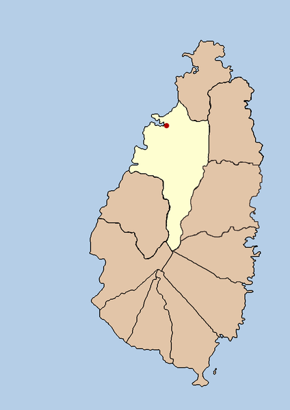
2. Saint Lucia is divided into 11 quarters. One of those quarters is named Castries, sharing the same name as the capital city located with its boundaries.

This map highlights the quarter of Castries on the island nation of Saint Lucia. The red dot indicates the location of the city of Castries.

This map highlights the quarter of Castries on the island nation of Saint Lucia. The red dot indicates the location of the city of Castries.

3. While about 20,000 people live in the city of Castries, between 60-70,000 live in the Castries quarter, an area that covers an area of 31 square miles.

4. The city of Castries is built in a grid pattern on reclaimed land.

5. Castries was founded by the French in 1650 when St. Lucia was purchased by Jacques Dyel du Parquet, the governor of Martinique. The quarter was named “Carénage” meaning “safe anchorage.”

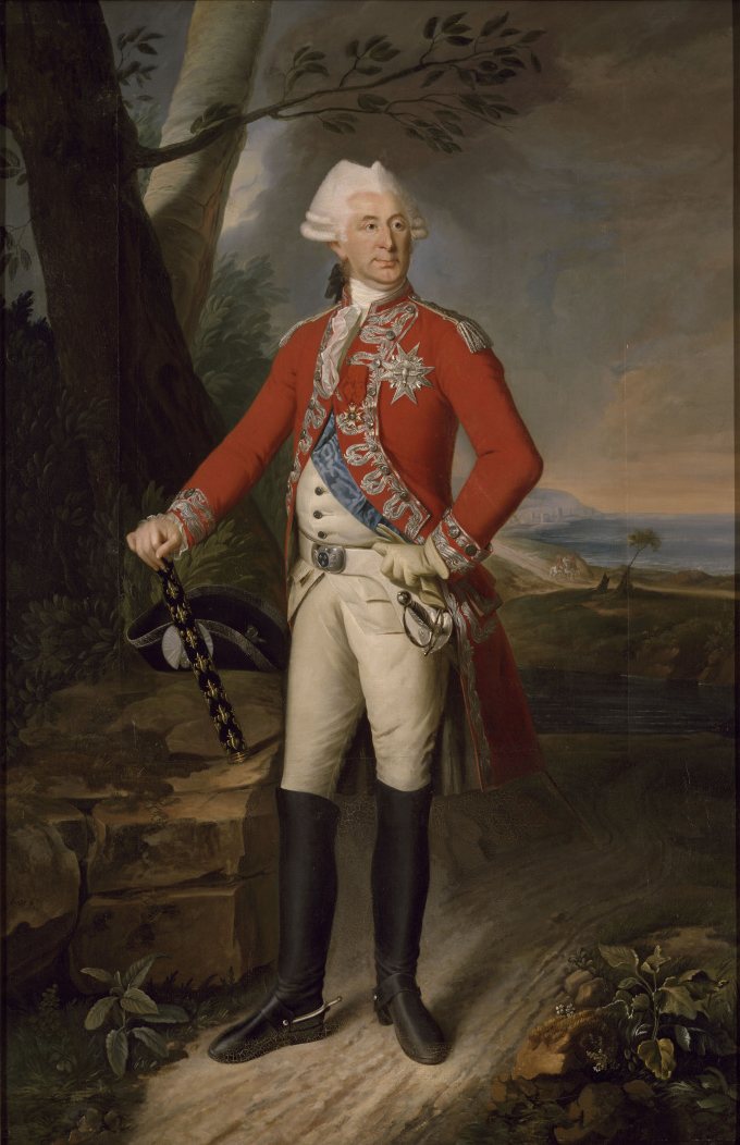
Charles-Eugène-Gabriel de La Croix, de Castries

Charles-Eugène-Gabriel de La Croix, de Castries

6. In 1756, the Carenage quarter of the island was renamed “Castries” after Charles Eugène Gabriel de La Croix de Castries, who commanded the French expeditionary force sent to St Lucia.

7. While France and England fought over Saint Lucia throughout the 17th and early 18th centuries, it was the British who built Castries into a major navel port between 1803 and 1844. The British protected this port with major fortifications on Morne Fortune, the hilltop overlooking the Castries harbor.

8. By 1900, Castries had become a major coaling station because it was the only Caribbean port capable of accommodating the British Royal Navy.

9. Castries saw action during During World War II. In 1942, a German U-boat sailed into the Castries harbor and sank two allied ships in 1942, including the Canadian ocean liner RMS Lady Nelson.

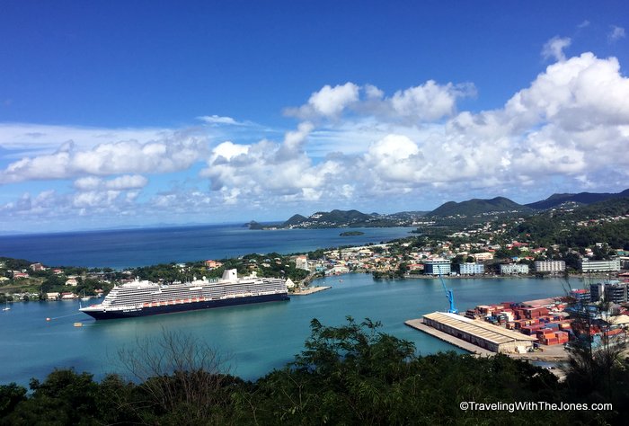
Holland America's ms Koningsdam cruise ship in the port of Castries, St. Lucia.

Holland America’s ms Koningsdam cruise ship in the port of Castries, St. Lucia.

10. Today, Castries is a port of call for cruise ships bringing approximately 600,000 visitors to Saint Lucia each year. The cruise ship passengers arrive through Pointe Seraphine, a duty-free shopping center at at the Castries Cruise Terminal.

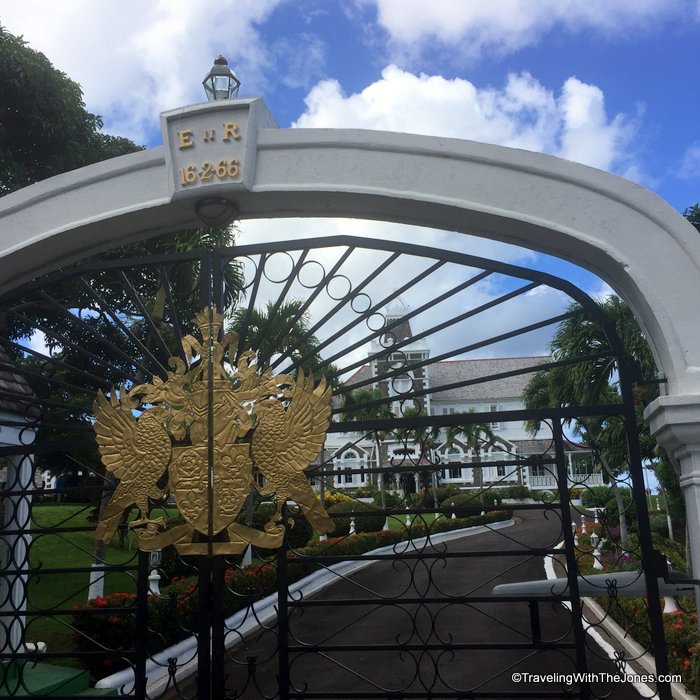
The Government House, located on Morne Fortune near Castries, St. Lucia.

The Government House, located on Morne Fortune near Castries, is the official residence of the Governor-General of Saint Lucia.

11. While Queen Elizabeth II is the Head of State of Saint Lucia, she is represented on the island by an appointed Governor-General. The Government House, located on Morne Fortune near Castries, is the official residence of the Governor-General of Saint Lucia.

12. In addition to being the capital city of Saint Lucia, Castries hosts the secretariat of the Organization of Eastern Caribbean States, and the headquarters of the Eastern Caribbean Supreme Court.

13. A number of international embassies and consulates are headquartered in Castries including the British High Commission and the Embassies of Brazil, France, Mexico, the Republic of China (Taiwan), and Venezuela. The Dominican Republic Consulate, Italian Vice Consulate, Jamaican Consulate, Netherlands Consulate and the Norwegian Consulate are also located in Castries.

14. The former Columbus Square at the center of downtown Castries was renamed Derek Walcott Square to honor the Nobel Prize-winning poet, Derek Walcott. Born in Castries on January 23, 1930, Mr. Walcott is a Saint Lucia poet and playwright whose works include the Homeric epic poem Omeros.

15. Castries is also the birthplace of Arthur Lewis, winner of the 1979 Nobel Prize in Economics.

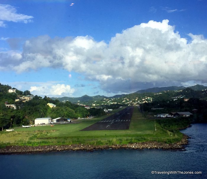
A view of the George F. L. Charles Airport runway from the deck of a cruise ship departing from Castries, Saint Lucia

A view of the George F. L. Charles Airport runway from the deck of a cruise ship departing from Castries, Saint Lucia

16. Castries is served by George F. L. Charles Airport, also known as Vigie Airport. When cruise ships sail by, the airport’s runway must be closed.  Hewanorra International Airport, near Vieux-Fort, is the island’s major international airport.

Learn more about Castries and Saint Lucia with these books:

The 2016 Economic and Product Market Databook for Castries, St. Lucia

101 Things To Do And Places To See In Saint Lucia

St. Lucia Dive Map & Reef Creatures Guide Franko Maps Laminated Fish Card

Have you traveled to Castries, St. Lucia? What fun fact can you add to this list?

Please share your thoughts in comments below, or by interacting with us on TwitterFacebookPinterest or Instagram.

Check out these other Fun Facts posts:

{ 0 comments }